Category: iOS
-

HOW MUCH TO MAKE AN APP? Website? what is right for me?
Easily calculate the cost of a mobile application http://howmuchtomakeanapp.com/ Easily calculate the cost of a website http://howmuchdoesawebsiteco.st/ Which is right for my project? http://appvswebsite.com/
-
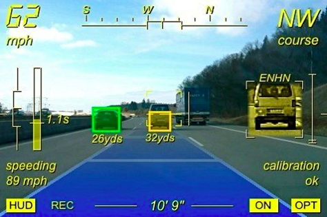
iOnRoad – Augmented driving
iOnRoad is a free augmented reality driving safety app.[1] It received the International CES 2012 innovation award.[2][3][4]The program uses the GPS feature, gyroscope and video camera stream of the native mobile device to monitor a vehicle’s position on the road, alerting drivers of lane departures and potential collisions with audio and visual cues.[5][6]iOnRoad has been…